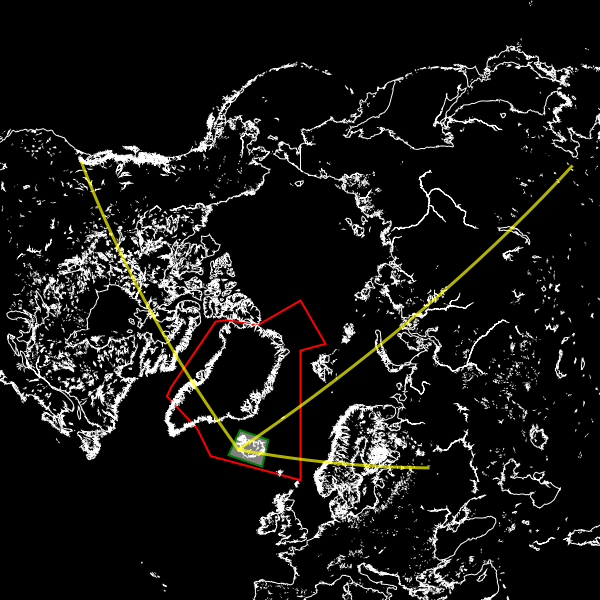
Custom shapes and lines
Pycoast can add custom polygons and lines, useful for outlining
special target areas. The following example shows how we might
use the add_polygon method to highlight the Reykjavik Air Traffic Control
area and an additional filled box around Iceland.
>>> from PIL import Image
>>> from pycoast import ContourWriterAGG
>>> img = Image.new('RGB', (600, 600))
>>> proj4_string = '+proj=laea +lat_0=90 +lon_0=0 +a=6371228.0 +units=m'
>>> area_extent = (-5326849.0625, -5326849.0625, 5326849.0625, 5326849.0625)
>>> area_def = (proj4_string, area_extent)
>>> cw = ContourWriterAGG('/home/esn/data/gshhs')
...
>>> REYKJAVIK_ATC = [(0.0,73.0),(0.0,61.0),(-30.0,61.0),(-39,63.5),(-55+4/6.0,63.5),(-57+45/60.0,65),(-76,76),(-75,78),(-60,82),(0,90),(30,82),(0,82)]
>>> ICELAND_BOX = [(-25,62.5),(-25,67),(-13,67),(-13,62.5)]
>>> cw.add_polygon(img, area_def, REYKJAVIK_ATC, outline='red',width=2)
>>> cw.add_polygon(img, area_def, ICELAND_BOX, outline='green', fill='gray', width=2)
>>> cw.add_coastlines(img, area_def, resolution='l', level=4)
>>> img.show()
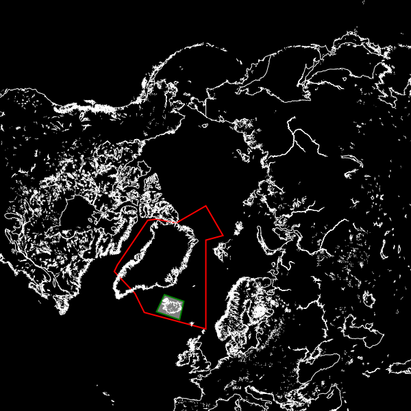
The add_polygon method accepts a list of longitude, latitude pairs.
An equivalent add_line method is also available which does not tie
the first and last coordinates in the list.
Now we can plot some air traffic routes from Keflavik to Seattle, Moscow and Beijing,
>>> ROUTE_KEF_MOS = [(-22.6056, 63.985), (-19.046655824698217, 64.2936159845089), (-15.41883293246517, 64.51404924194419), (-11.744200494490052, 64.64399069686961), (-8.046778033221322, 64.6820416591038), (-4.351563677581442, 64.62778714494442), (-0.6834599011921236, 64.48181810544278), (2.9337905930008565, 64.24569983825512), (6.478548138904879, 63.92189044240429), (9.932010650466118, 63.513618932636106), (13.278688573156892, 63.02473642018875), (16.506610526365268, 62.459555054119136), (19.607285620724404, 61.82268835291907), (22.575472462848946, 61.118903806204194), (25.408815405909454, 60.352995069199515), (28.107407514323345, 59.52967751291583), (30.673330797710015, 58.65350788682086), (33.110211639277665, 57.7288266642078), (35.42281629953696, 56.75972029885026), (37.6167, 55.75)]
>>> ROUTE_KEF_SEA = [(-22.6056, 63.985), (-28.15308892820336, 65.36580325755281), (-34.26244035327647, 66.52172028653052), (-40.896187287785146, 67.41807846160079), (-47.960443294166176, 68.02301075853937), (-55.302469834902446, 68.31206181696378), (-62.72513195737088, 68.27259499211274), (-70.01742497152813, 67.90637421611629), (-76.99054572503543, 67.22919099479928), (-83.50520476774184, 66.26770704836584), (-89.48175180569157, 65.05485573003652), (-94.89452260904564, 63.62539374850556), (-99.75771059724035, 62.012611982850714), (-104.1099689970044, 60.24644267746881), (-108.00184199066507, 58.352707879886715), (-111.48717146239099, 56.3531052759957), (-114.61800147728289, 54.26558085318135), (-117.4419933502085, 52.104852107803715), (-120.00142613885524, 49.88294778482337), (-122.3331, 47.6097)]
>>> ROUTE_KEF_BEI = [(-22.6056, 63.985), (-17.489150553128045, 67.07686353046147), (-10.93541135202904, 69.95803521761742), (-2.422591560170639, 72.52376059083646), (8.601530816977142, 74.6151942209109), (22.350514164676376, 76.01770036199035), (38.03768523094268, 76.51449133498859), (53.7147372147881, 76.00872266593849), (67.44042282956654, 74.598879606615), (78.43970951791597, 72.50222030140003), (86.9320528199369, 69.93299364768527), (93.47049967796295, 67.04949777818322), (98.57586637530908, 63.95606630048991), (102.64426083795271, 60.71933633909033), (105.95716114438707, 57.38212969906091), (108.71149093382456, 53.97256160920469), (111.04582088648519, 50.509589240989264), (113.05910256207024, 47.00634823698568), (114.82328673157406, 43.472181706860376), (116.3917, 39.9139)]
>>> cw.add_line(img, area_def, ROUTE_KEF_MOS, outline='yellow',outline_opacity=180,width=3)
>>> cw.add_line(img, area_def, ROUTE_KEF_SEA, outline='yellow',outline_opacity=180,width=3)
>>> cw.add_line(img, area_def, ROUTE_KEF_BEI, outline='yellow',outline_opacity=180,width=3)