Usage
Pycoast can be used to add coastlines, borders and rivers to a raster image if the geographic projection of the image and the image extent in projection coordinates are known
Pycoast can add contours to either a PIL image object:
>>> from PIL import Image
>>> from pycoast import ContourWriterAGG
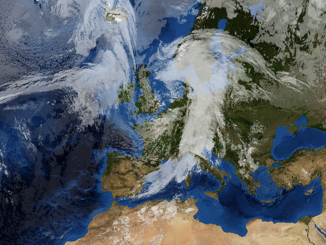
>>> img = Image.open('BMNG_clouds_201109181715_areaT2.png')
>>> proj4_string = '+proj=stere +lon_0=8.00 +lat_0=50.00 +lat_ts=50.00 +ellps=WGS84'
>>> area_extent = (-3363403.31,-2291879.85,2630596.69,2203620.1)
>>> area_def = (proj4_string, area_extent)
>>> cw = ContourWriterAGG('/home/esn/data/gshhs')
>>> cw.add_coastlines(img, area_def, resolution='l', level=4)
>>> cw.add_rivers(img, area_def, level=5, outline='blue')
>>> cw.add_borders(img, area_def, outline=(255, 0, 0))
>>> img.show()
or to an image file:
>>> from pycoast import ContourWriterAGG
>>> proj4_string = '+proj=stere +lon_0=8.00 +lat_0=50.00 +lat_ts=50.00 +ellps=WGS84'
>>> area_extent = (-3363403.31,-2291879.85,2630596.69,2203620.1)
>>> area_def = (proj4_string, area_extent)
>>> cw = ContourWriterAGG('/home/esn/data/gshhs')
>>> cw.add_coastlines_to_file('BMNG_clouds_201109181715_areaT2.png', area_def, resolution='l', level=4)
>>> cw.add_rivers_to_file('BMNG_clouds_201109181715_areaT2.png', area_def, level=5, outline='blue')
>>> cw.add_borders_to_file('BMNG_clouds_201109181715_areaT2.png', area_def, outline=(255, 0, 0))
Where the area_extent is the extent of the image in projection
coordinates as (x_ll, y_ll, x_ur, x_ur) measured at pixel edges.
The argument to ContourWriterAGG must be replaced with your GSHHS_DATA_ROOT.
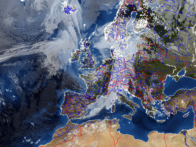
The resulting (not so pretty) image shows the effect of the various
arguments. The resolution keyword argument controls the resolution of
the dataset used. It defaults to ‘c’ for coarse. Increasing the resolution also
increases the processing time. The level keyword argument controls the
detail level of the dataset used. It defaults to 1 for the lowest detail
level. See method docstrings for information about other possible argument
values.
Example with tuple
Creating an image with coastlines only:
>>> from PIL import Image
>>> from pycoast import ContourWriterAGG
>>> img = Image.new('RGB', (425, 425))
>>> proj4_string = '+proj=geos +lon_0=0.0 +a=6378169.00 +b=6356583.80 +h=35785831.0'
>>> area_extent = (-5570248.4773392612, -5567248.074173444, 5567248.074173444, 5570248.4773392612)
>>> area_def = (proj4_string, area_extent)
>>> cw = ContourWriterAGG('/home/esn/data/gshhs')
>>> cw.add_coastlines(img, area_def, resolution='l')
>>> img.show()
Example with AreaDefinition
Instead of a tuple for area_def a pyresample
AreaDefinition object can be used. The code
below produces the same image as above.
>>> from PIL import Image
>>> from pycoast import ContourWriterAGG
>>> from pyresample.geometry import AreaDefinition
>>> img = Image.new('RGB', (425, 425))
>>> area_def = AreaDefinition('my_area', 'Area Description', 'geos_proj',
...     {'proj': 'geos', 'lon_0': 0.0, 'a': 6378169.00, 'b': 6356583.80, 'h': 35785831.0},
...     425, 425,
...     (-5570248.4773392612, -5567248.074173444, 5567248.074173444, 5570248.4773392612))
>>> cw = ContourWriterAGG('/home/esn/data/gshhs')
>>> cw.add_coastlines(img, area_def, resolution='l')
>>> img.show()